UgCS Pro Perpetual
Call to OrderFrontier Precision is currently adding items to the Shop, so please contact us at 800-359-3703 to order or for more information on this item.


Save Time and Money
• No need to learn diverse software – UgCS enables supports for the majority of drones
• The import and route creation from customer provided KML data will save 50% of your time
• Save days of traveling and before leaving the site, validate acquired data by stitching images with the offline processing software UgCS Mapper
Increase Surveying Productivity
• Increase the data capture productivity at least 2 times with the inbuilt automatic photogrammetry planning tool
• Plan and fly missions without internet connection even in a desert area with offline map caching capability
• Fly long routes, resuming flights from a certain waypoint after battery change
Higher Flight Safety
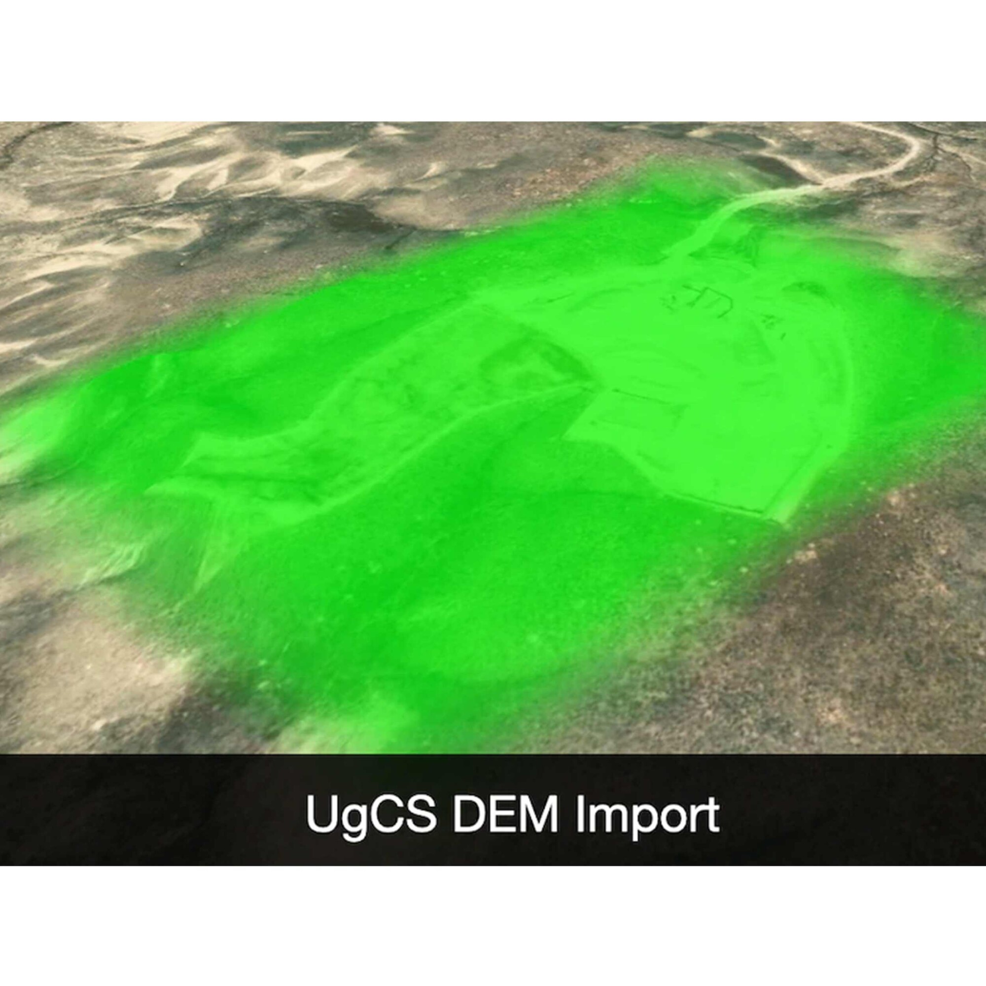
• Use pre-installed or import more precise DEM data to increase accuracy and safety for missions with terrain following
• Adjust the allowed flight range and No Fly Zones to fly according to regulatory requirements
FEATURES:
Automated drone mission planning, built-in Photogrammetry and Geotagging tools, Digital Elevation Model (DEM) and KML file import enables map customization, and battery change option for long routes make UgCS an effective solution for large area surveying.
Map Customization | Offline Usage
• Create Routes from KML
• Plan Surveys with Terrain Following
• Import DEM for Safer Mission Planning
• Georeferenced Image Import as Map Overlays
Mission Planner | Drone Control
• Immersive 3D Mission Planning Environment
• Drone Survey Planning Tools
• Facade Scan Tool
• Elevation Profile
• Telemetry Window
• Automatic Flight Mode (Waypoints) and Direct Drone Control
• Software Emulator
Post-flight Analysis and Image Processing
• Geotagging
• Telemetry Player
No-fly Zones
• No-fly Zones – Airport Registry
• Create Custom No-fly Zones
• Fly Zone Limits for Routes
UgCS Applications
• Land Surveying | Mapping
• Powerline Inspections
• Farming and Agriculture Monitoring
• Emergency Services / Search and Rescue
• Ground Station Software for Real Estate
Related products
-

Trimble Business Center Advanced – Dongle License
Trimble Business Center Advanced – Dongle License
Call to OrderFrontier Precision is currently adding items to the Shop, so please contact us at 800-359-3703 to order or for more information on this item.ONLY AVAILABLE FOR DELIVERY IN ND, SD, MN, CO, AK, MT, ID, HI, WY, OR, & WA.Quick View -

Applanix POSPac UAV with 1-year Maintenance

Applanix POSPac UAV with 1-year Maintenance
Call to OrderFrontier Precision is currently adding items to the Shop, so please contact us at 800-359-3703 to order or for more information on this item.ONLY AVAILABLE FOR DELIVERY IN ND, SD, MN, CO, AK, MT, ID, HI, WY, OR, & WA.
Quick View -

Catalyst 1 Meter

Catalyst 1 Meter
Call to OrderFrontier Precision is currently adding items to the Shop, so please contact us at 800-359-3703 to order or for more information on this item.ONLY AVAILABLE FOR DELIVERY IN ND, SD, MN, CO, AK, MT, ID, HI, WY, OR, & WA.
Quick View -

Trimble Access – General Survey; Perpetual License


Trimble Access – General Survey; Perpetual License
Call to OrderFrontier Precision is currently adding items to the Shop, so please contact us at 800-359-3703 to order or for more information on this item.ONLY AVAILABLE FOR DELIVERY IN ND, SD, MN, CO, AK, MT, ID, HI, WY, OR, & WA.Quick View